
Satnav without the satellites
As far back as 1930 there was a device available for helping navigate your shiny new horseless carriage. It is an interesting example of using the limited technology of the time to get you from A to B with a slightly lower chance of getting lost.


Imagine you are in an unfamiliar city, driving a car with no locals on board. The specifics of how you got here are not important to the story so feel free to make them up. You've got somewhere to be for reasons known only to you.
Out of habit you reach for your phone to load your favourite maps app - Bing or something - to get directions to your destination. You phone disappears in a puff of chronistic correction, for it is 1930 - the specifics of that are important to the story - and now you are lost, and the car in your imagination looks very different to how it looked in the previous paragraph.

You could pull over and ask someone directions - they might get a pencil and paper out and sketch something vaguely useful, but after half a dozen turns and landmarks you would probably tune out, forget what was said and be just as lost a bit further down the road. Buying a map and navigating yourself is another option but difficult to do while you are driving. Your small children in the back are too young to read a map. Would you believe that there is actually a form of in-car navigation that you can use.
Iter-Auto
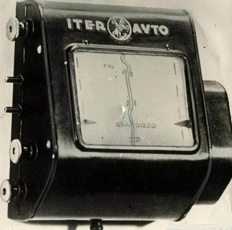
In 1930 there was a device available for helping navigate your shiny new horseless carriage. Though most people could not even afford a car, let alone additional extras, it seems unlikely that it was mass produced or widely available. It is an interesting example of using the limited technology of the time to get you from A to B with a slightly lower chance of getting lost.
The device came with maps on a long paper scrolls. The first task was to identify which scroll had both your current location and your destination on it. And they also had to be connected on the map in the right direction. Once you have identified the right scroll, simply load it into the dash mounted device, wind it until the arrows point to where you currently are - and start driving.
The Iter-Auto was connected to your speedometer which controlled the speed at which it scrolled the map for you. A clever advantage that it had over a previous wrist mounted device from a couple of years earlier that required manual winding as you drove which sounds like a distraction waiting for an accident to me. As long as you didn't make any unexpected turns, and wanted to go somewhere further along the scroll then the map will move in real-time, showing you landmarks such as bridges or hotels or airship terminals along the way.
If you didn't know where you were to start with you were out of luck. If you made an unexpected turn and got off track you were out of luck. If your destination was not one the Iter-Auto crew had thought of you were out of luck. Seems like you were lucky to get there at all with this device, but like all technological innovations someone has to start somewhere. You wind the correct scroll into the device and start driving, following along with the moving map.
Cassette Navigation
41 years later you still haven't reached your destination, but technology has moved on a bit. Your children in the backseat are now middle aged, chanting "are we there yet?" and still no help with navigation.
Your car now has a cassette player and as long as you don't want to listen to music, it can be repurposed as your updated navigation system. Spoken instructions are much easier to follow than reading a map while driving so you have high hopes of finally reaching your destination.
This cassette nav gadget sits out of the way under your dashboard, there is no screen to distract you anymore. You simply need to measure your tyres, select the right circuit board, remove the computer from the dashboard, insert the circuit board firmly into the correct slot, replace the device in it bracket under the dashboard, connect it to your car stereo and odometer, select the correct cassette that starts where you currently are and drives past where you want to go, pop it into your car stereo and start driving. Much easier than having an argument with Google's voice recognition.
The cassette plays spoken instructions such as
In two hundred yards, turn left. BEEP
In one hundred and fifty yards, make a sharp right. BEEEEEP
In twenty-five years turn on GPS. BEEEP
and so on.
The beeps are important. As you drive, each instruction is played at the right time, guiding you to your destination. The duration of the beep tells the primitive computer how far you need to drive before the next instruction should be played. The odometer, and the carefully selected circuit board that matches your tyre size, allows the device to know how far you are driving. In 41 years the technology hasn't really solved the problems of the Iter-Auto - you still need to start and end somewhere the manufacturers expected, carefully select the correct cassette and ensure that you do not, ever, deviate from that route or you are at least as lost as you were to start with.
Your grown kids start fighting in the back, while you are temporarily distracted you miss a crucial turn and are once again lost.
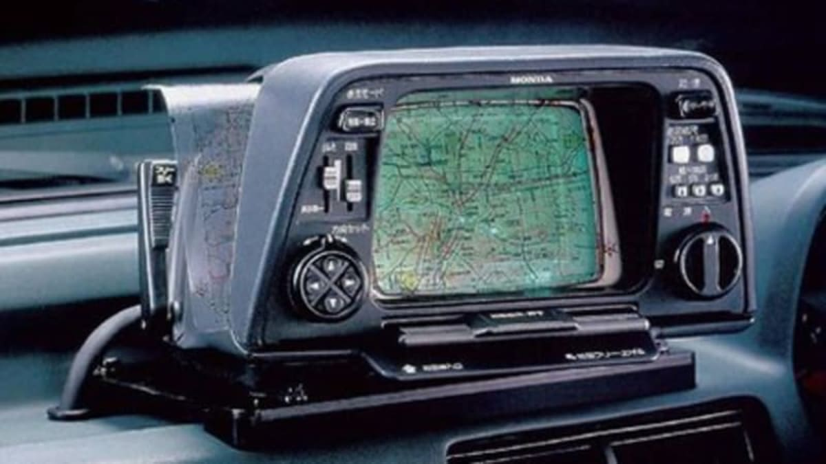
The Electro Gyrocator
A mere 10 years later, still on the literal trip of a lifetime, you've upgraded to the latest technology, an $8,000 Honda Accord with a $3,000 Electro Gyrocator installed. Yes this is the 1980s and not a 1950s sci-fi B-movie and the absolutely fantastically named Electro Gyrocator is the latest in in-car navigation systems.
Transparent film, CRT illumination, if even comes with a whiteboard marker so you can circle your destination and plan your route right on the map!
You put the map into the device and calibrate it so that your current location is in the center crosshairs - like all devices to date you need to know where you are starting from. The clever part here is that with a connection to your car's transmission and a helium filled gyroscope to detect your car's movement, the Electro Gyrocator can move the map in coordination with your car and always show your position. Finally solving the problem of what to do if you turn the wrong way. You do have to plan and follow your own route though, and the map is very small. The biggest problem at the time was the price, nearly half the price of the car itself so it wasn't widely adopted.
Your eldest child celebrates their 60th in back and passes you a piece of birthday cake. You are running out of excuses for continuing to be lost, the specifics are not important to the story so feel free to make something up.
Etak Navigator
You don't have to wait long for an upgrade relatively speaking. 4 years later the Etak Navigator is available. This thing finally uses a compass - technology was only 2,200 years young and yet to prove itself, but Etak took a risk and developed their navigation system using this new-fangled device. Maps were stored digitally on loads of tapes and the device had similar processing power to the PCs of the day. Despite being financed by the guy who founded Atari, it couldn't play Pong or Kerbal Space Program or even Daley Thompson's Decathlon. (There is an enduring connection to Asteroids though!)
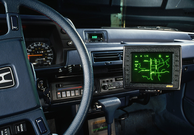
The Navigator had a green vector screen that displayed the maps and used dead reckoning to update your position in the system. It really only needed to be calibrated when first installed as it could self-correct any small errors by matching your location to roads. You could probably throw the whole thing out by hooning through a field or along a beach, but as long as you stayed on roads you'd be fine. At least until Doc Brown came back from the future later that year and made roads obsolete.
Etak pioneered a number of mapping technologies, digital maps, triangle car markers, error correction, routing algorithms and so on. The descendants of these are still used in navigation systems today. A key one is the ability to geocode addresses into latitude and longitude - allowing the map to actually guide you to your destination. Speaking of descendants yours are nearing retirement age and bugging you for ice-cream. You make a diversion down to the beach and after a short, but navigationally fatal, off-road adventure along the shore you pick up some ice-creams to appease your passengers.
With the calibration of your Navigator thrown off you are once again lost.
Satellites
Ok we weren't navigating with satellites, but this trip has taken a really long time.
The first GPS satellites were launched in 1978, back when you were still navigating by cassette tape. President Ronald Reagan (you might've heard of him) authorised GPS for civilian use in 1983, and it was originally aircraft that took him up on that offer. 1989 saw the first hand-held GPS units for about the same price as your Electro Gyrocator.
GPS is certainly not vintage tech - it uses geostationary satellites, atomic clocks and both the special and general theories of relativity and calculations involving the speed of light. Highly accurate clocks are needed on both the satellites and the device on the ground to work out your position on the ground (or in the air). To correct a misconception the GPS satellites themselves don't know where you are, they essentially just broadcast their position and time - given enough of them in rage (at least 3, ideally more) then your device on the ground can work out latitude, longitude and altitude based on how long it took for the signals from those satellites to get to you. It's a big advantage compared to rummaging through scrolls or cassettes or transparent film and finding your position manually. You position can also be updated as you drive so you always know where you are.
1990 saw the first production car with Satellite navigation built in and throughout the 90s there were a wide range of approaches and improvements to Satnav.
Without widespread mobile internet the maps had to be preloaded and stored somewhere. There were hard drive solutions, and CD-ROM solutions and DVD solutions and of course SD cards. If your maps were out of date you had to buy new ones in order for your navigation to work - but for the most part the challenges we've had so far were solved.
The device knew where you were starting from, where you currently were, if you missed a turn or got diverted due to road closures etc. Finally the geospatially challenged and get to where they needed to go.

And that's exactly how you arrive at your destination after a decades long trip. You pull into the carpark at the Shady Acres Retirement Home and let the kids out of the car.
"Welcome to your new home!"
You let them settle into their new accommodation before heading off again, safe in the knowledge that technology ensures that you'll never ever get lost again.
Credits
Photo by NisonCo PR and SEO on Unsplash
Photo by Anshu A / Unsplash
Iter Avto: The antique route show: The 'sat nav' from 1930 which used a map on a scroll | Daily Mail Online
The automated in-car navigator that predated satellites (engadget.com)
Trying to find the name/brand of this toy. : nostalgia (reddit.com)
Cassette-based car navigation - BBC Archive
Photo by Axel Antas-Bergkvist / Unsplash